Quinault Indian Nation Plans for Relocation

Quinault Indian Nation Plans for Relocation

Equity & Justice

Some Indigenous communities have deep ties to the environment and rely on natural resources for their traditions, food, shelter, medicine, and overall livelihood. As a result, Indigenous communities may be uniquely harmed by climate change and environmental degradation. 

Due to their small size and their commitment to minimal infrastructural development, many tribal communities are finding the habitability of their land undermined by increased exposure to droughts, floods, and fires, and a diminished ability to produce food. 

Compounding this over-exposure to climate hazards, Indigenous Peoples are less likely to benefit from flood insurance and related protections. A review by the Federal Emergency Management Agency (FEMA) showed that of the 573 federally recognized tribes, fewer than 50 are in the National Flood Insurance Program. Additionally, of the 59,303 properties that received FEMA grants since 1998 to prepare for disasters, only 48 were on tribal lands. 

Project Summary

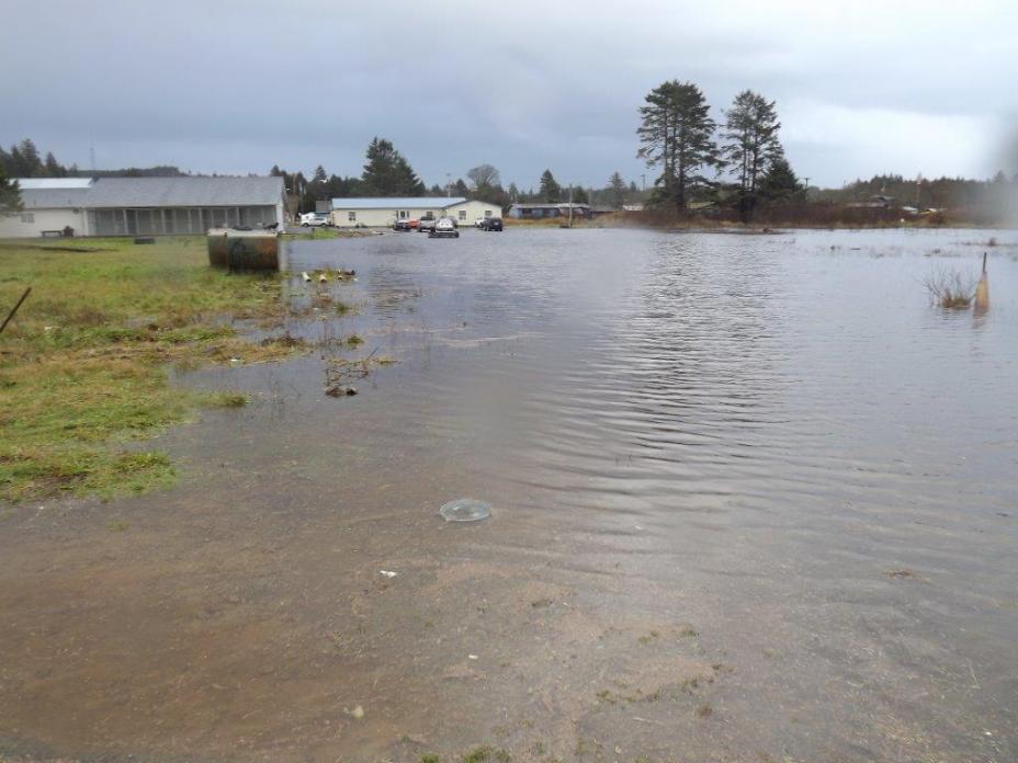
The Quinault Indian Nation village of Taholah is located within Washington State at the confluence of the Quinault River and the Pacific Ocean. Taholah is particularly vulnerable to sea level rise, storm surge and river flooding – all of which are expected to worsen with climate change. The village is also concerned with the potential threat of tsunamis, which has not been scientifically connected to climate change. The village's vulnerability was highlighted in early 2014 and again in 2015 when storm surge and intense rains caused flooding, landslides and culvert failures in the lower-laying areas of the village.

To better understand its risk into the future, the Nation conducted a vulnerability assessment with the assistance of a Social and Economic Development Strategies grant from the Administration for Native Americans. The resulting plan – which is incorporated numerous community discussions and forums – centers on relocating 650 residents and vulnerable community facilities a half-mile away from the existing village. The new village will be in a location well above the tsunami and flood zones.

The relocation plan, if implemented, prepares the village to be resilient to anticipated climate change impacts such as storm surge and sea level rise as well as protecting the village from tsunamis; the expected inundation area from a 40-foot wave matches or exceeds the anticipated threat from storm surge and sea level rise resulting from climate change.

Two additional points are worth noting. First, the Nation considered climate (sea level rise, storm surge and river flooding) and non-climate (tsunami) risks together in determining its vulnerability and adaptation options. Second, rather than conducting a separate climate adaptation analysis, the Nation used a tsunami threat standard and FEMA's 1-in-100 year flood zone as the basis for selecting its tsunami risk and climate vulnerability adaptation strategy.

Flooding from the Quinault River and Pacific Ocean across the Quinault Indian Nation Village of Taholah.

How did they do it?
ActionApplicable Resources

Identified threats

  • Identified key climate, weather, and community vulnerabilities. These threats included anticipated climate threats from sea level rise, storm surge, and river flooding.

Determined vulnerabilities (including the most vulnerable population) and adaptation options

  • Identified most vulnerable community areas; which threatened more than 600 tribal and non-tribal residents, many of whom are elderly or very young.
  • Determined the need to relocate population.
  • EPA’s Coastal Storm Surge Mapper illustrates historical hurricane tracks, strike frequency, and potential areas of coastal flooding and inundation from storms.

Selected relocation as its adaptation action

  • The community identified 200 acres near the upper village as a potential relocation option due to its high elevation (120 feet above sea level) and location outside the tsunami hazard zone and FEMA 1-100 year flood zone.
  • Relocating also enables the Nation to incorporate smart growth techniques including low-impact development and green infrastructure to better prepare the community for the future climate.
  • EPA’s Tribal General Assistance Program (GAP) grants federally recognized tribes and tribal consortia for planning, developing and establishing environmental protection programs in Indian country.

Engaged residents in the selected adaptation

  • The Nation actively engaged its members in the development of the Village Relocation Master Plan. Multiple stakeholder and community meetings have been held and specific outreach efforts addressed the most vulnerable population by targeting schools and tribal elders. These efforts included community surveys and design charrettes to better identify the desired community layout. The preliminary plan includes a multi-use center for seniors, day care and early school head start programs.
  • The final relocation master plan (expected to be completed in 2016) will detail the overall strategy and allow for a cost and time estimate.
  • EPA's Being Prepared for Climate Change guides users to develop a risk-based climate change adaptation plan consisting of a vulnerability assessment and an action plan to reduce the most pressing risks.

Similar Case Studies